The estate was built on the site of a row of villas, one of which - Holmwood (82 Langside Avenue) - was home to Charles Rennie Mackintosh's father in the 1890s. Charles himself lived there 1892-5.
You then go onto Deanston Drive, here's an aerial view (Tantallon to left, Deanston to right):
On the right as you enter Deanston Drive is St Helens Catholic Church. (1897, John Bennie Wilson).
On your way from Checkpoint 1 to 2, you will probably choose to go through Cathcart Cemetery: Amongst those buried here are the suffragette Henria Leech Williams and Margaret Jefferson, actress and mother of Stan Laurel, who lived in Glasgow as a boy. Here's a 1991 aerial view, looking North:
You'll cross the "Halfpenny Bridge" as you go through Linn Park. Built between 1811 and 1820, this is the oldest complete iron bridge in Glasgow, and was built as part of the driveway to Linn House.
Linn House was built c 1828, enlarged 1852 by Charles Wilson:
From the trig point you descend through the woods around the back of Linn Crematorium, (1962, T S Cordiner) "A Beaux Arts-influenced modernist complex".
You then go up to Cathkin Braes: this 2014 photo shows the venue for the Commonwealth Games mountain biking event. Built on the site of the Mitchellhill high flats, demolished in 2005, this is now a mountain biking centre with several new bike trails.
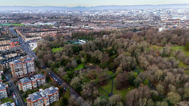
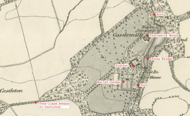
On your descent from Cathkin Braes, you will pass through the Castlemilk estate. The estate, which was in the Stuart family from the 13th century, was sold to the City in 1938 for one of the large peripheral housing estates built after 1954. Castlemilk House, which dated back to the late medieval period but had been greatly altered and extended from the 18th century, was demolished in 1972. This 1969 photo is taken from the fishpond :
The Stables for the house (built c.1800) still stand, and were converted into offices for the Castlemilk Housing Association in 2006. The Gothic single-arch bridge (visible in the photo) was remodelled in 1833, probably by David Hamilton. The Burn fed the reservoir of the Burnside Weaving Factory. Lower down it becomes the West Burn before merging with Malls Mire Burn to discharge into the Clyde as the Polmadie Burn (more on this in the To the Dead and Back blog).
On your way up to the checkpoint you enter Kings Park and go close to Kings Park House:
Known as Aikenhead House, this was built in 1806, for John Gordon, a Glasgow merchant in the West India trade. The mansion sits in a hollow among several small drumlins perched on the steep slope rising from Polmadie through King's Park, a fine Corinthian porch on west front. Deep one-and-a-half-storey wings, protected by giant pilasters, added 1823, David Hamilton. Converted to flats 1985. To the south are the early 19th-century brick-built walled gardens, a stable block and an 1885 mannerist two-tier ashlar sundial, on elaborate base with a tall obelisk finial. (a reproduction of the 1635 Newbattle sundial).
This aerial view looks east, with the Checkpoint just out of shot up the hill to the left of the House:
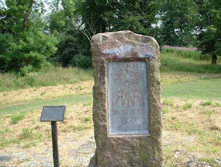
Court Knowe (CHECKPOINT): A stone marks the spot where Mary Queen of Scots is alleged to have stood to watch the battle of Langside in 1568. This is, however, unlikely as the nearby castle was owned by Sir William Semple, who fought on the opposing side in the battle.
Cathcart Castle (CHECKPOINT). 15th Century, demolished 1980.
Here it is in 1941 from the other direction:
And here's a 1889 photo of Cathcart House (which was in Linn Park, you can still see the flat grassy area where it stood) and the Castle:
Just off the route is the Snuff Mill, bridge and Lindsay House, seen in this aerial view:
Lindsay Tenement built 1863, with his initials carved above the door.
When you go down into Cathcart you will pass close to the B listed Holm Foundry buildings in Newlands Road, Cathcart, built in 1912 to designs purchased from Albert Kahn's Trussed Concrete Steel Co in the USA.
The firm of G. & J. Weir built the Foundry on the site of an old steading,
primarily to produce a range of marine auxiliary machinery, including the world-famous Weir boiler feed pump.
During WW1 the company expanded the complex, and made more
aircraft than any other Scottish firm.
Here's a 1956 OS Map:
Nearby is the former Wallace-Scott Tailoring Institute, built in 1912. (later Electricity Board, now flats):

(depending on your route choice!) you may go past Millbrae Crescent: 1876-7, built by Robert Turnbull, the partner of Alexander 'Greek' Thomson. Long crescent of houses, essentially 'Greek' Thomson in style, with Greek and Egyptian details.

Then as you go up Millbrae Road, you pass the old Miller's Cottage on your left (there were once 2 mills here, a paper mill and a meal mill.)
The CHECKPOINT (ie Mansionhouse Gardens) is on the site of Langside House (Robert Adam, 1777, demolished in the 1950s)
Rawcliffe (1862) at 29 Mansionhouse Road is now the area's grandest house. Built as a private house, it was later a Carmelite Convent from 1919 to 2007 and is now flats.
Next door at No 27 is another villa that was the Boswell Hotel. Next door again, at No 25, is the Greek Thomson designed double villa, two houses built back to back (1856-7):
Then you go past the Langside Battlefield Monument, (1887, Alexander Skirving). This commemorates the Battle of Langside (13 May 1568) which was the final defeat for Mary Queen of Scots at the hands of the Regent, Earl of Moray (regent to the infant James VI).
And nearby is the Langside Hill (Free) Church (now the Church on the Hill pub) 1896, also by Alexander Skirving. The Greek Ionic temple above entrance porch, is in a 'Greek' Thomson-like composition. It ceased to be a church in 1975 and was converted in the 1990s.
Both monument and church are shown in this photo:
Just below the monument is the old Victoria Infirmary (built 1888-90), now (2025) being converted to flats:
Here is an aerial view before redevelopment:


.jpg)


Comments
Post a Comment