East Hills Blog (complete)
After exiting the Necropolis and climbing up Wishart Street you come onto Alexandra Parade and pass close to the former Wills Cigarette Factory (now City:Park and A-listed, photo below). Built in 1953, at its height it employed 3500 people. It closed in 1990.


Behind the building - on Craigpark- is the Our Lady of Good Counsel RC Church (Gillespie, Kidd & Coia, 1964-5, A-listed).
Just before Alexandra Park, you cross the now culverted Molendinar Burn (see PtoP blog for its history):


Then, as you turn left onto Shettleston Road, you go past the site of the Dyewood Mills Chemical works, seen in this 1950 photo, with the cross beyond.
50.jpg)


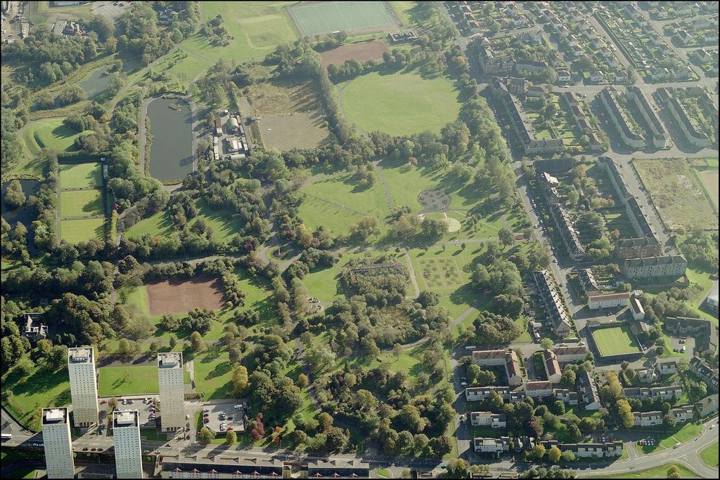
The section of London Road from Celtic Park to Auchenshuggle runs across the bottom left hand corner of the photograph, with the River Clyde winding through fields below it. Near the centre is the large expanse of Tollcross Park, just north of Tollcross Road and south of Shettleston Road.
The prominent road running across the top of the image is the busy Edinburgh Road, with Cumbernauld Road leading off diagonally from the left. The route of the Monkland Canal is clearly visible north of the Edinburgh Road, its route subsequently followed closely by the M8 Motorway. The fields in the top right corner disappeared under the post-war housing estates built at Cranhill (where work appears to be underway in this photograph) and Ruchazie:

You then go through the west part of Shettleston and up through Greenfield Park, over the A8 Edinburgh Road and on up to Cranhill Water Tower (CHECKPOINT). As you approach the tower along Skerryvore Road, you pass the site of the house where Angus and Malcolm Young spent their early years. Then their family emigrated to Australia and the brothers formed AC/DC.
The water tower - built in 1951 - is unique for having a square tower, in contrast to the round ones in nearby Garthamlock. Around its base are now a series of sculptures by Andy Scott (of Poseidon, three sirens and a mermaid) and there's a lovely little garden with a lighthouse map nearby. Andy is better known for the Kelpies sculpture in Falkirk.
The Cranhill housing estate was built in the early 1950s, and redeveloped in the late 1990s. This photo is from the 1950s, showing the tower on the right, with the canal beyond:

The streetnames take the names of lighthouses (Bellrock, Skerryvore etc). The three 1963 tower blocks (see photo below), just by the bridge you take to cross the M8, still stand.
Cranhill developed a range of social problems including an illegal drug trade and for a time the media dubbed it "Smack City".
Other famous Cranhill residents include Scotland footballer Pat Nevin actor Billy Boyd who was in Lord of the Rings.
The nearby Cranhill Park is now a protected habitat for water voles, unique in Scotland.
This photograph from 1987 shows the M8 Motorway, looking east from Gartcraig Bridge. The three multi-storey blocks in Cranhill in the background were built on what were once waste tips, forming a popular playground for children known locally as the "Sugarollie Mountains" (Sugarollie is a Glaswegian term for liquorice).
This stretch of the M8 is often referred to as the Monkland Motorway, as it was built on the bed of the Monkland Canal. This was once the most profitable canal in Scotland, carrying coal, iron, steel, timber and lime from the Coatbridge area to Glasgow, but by 1950 it had been abandoned. When the demand for a Glasgow-Edinburgh motorway became overwhelming (the first section opened in 1964), the canal provided a natural route through the east end. The canal was infilled in 1972, and this section of the M8 opened a few years later.


As you go out of the park you may pass Breeze's Tower (also known as Balgray Tower) on Broomfield Rd (B-listed, c 1830).

AS you go along Keppochhill Rd towards Sighthill Cemetery, you pass this mural celebrating the Cowlairs Incline (the route from Queen St to the old Cowlairs station up which trains had to be hauled, until they became powerful enough to do the job unaided!)

The iron gates to Sighthill Cemetery,are in an ornate Greek style and made in 1839. The cemetery opened in 1840. Perhaps the most famous people to buried at Sighthill are Andrew White, John Baird and Andrew Hardie. The last two were executed for treason for their involvement in the "Radical Rising" of 1820. They were buried in paupers' graves in Stirling, but their remains were brought back to Glasgow in 1847 and re-interred at Sighthill. Andrew White was one of nineteen others whose death sentences were commuted and were transported to Australia for their part in the abortive uprising.

Adjacent is the Lodge (also 1839) a Building at Risk sadly.

As you go down and out of the cemetery and onto Springburn Road you pass the front of what was the St Rollox Works, known locally as the Caley - after the Caledonian Railway Company which built it in 1856. It closed in 2019. The remaining buildings are Cat B listed. This 1954 photo looks East:

You then go into Roystonhill, an area which used to be called the Garngad until 1942. The 1925 photo below shows the slum housing of the time. A heavy cloud of polluted air hangs over the area, produced by the many heavy industrial works:

Garngad became heavily industrialised in the 19th century, with the establishment of flax and cotton mills, iron and chemical works and railway works. The tenements that were built to house incoming workers were of poor quality, with outside toilets, leading to overcrowding and insanitary conditions. Diseases such as tuberculosis were rife, and the Garngad slums were regarded as some of the worst in Europe.
Garngad was the scene of one of Glasgow Corporation's earliest major slum clearance programmes, beginning in 1933. Many of the residents moved to the new scheme in nearby Blackhill, and those that stayed could live in the new housing that was built.
The checkpoint is at Roystonhill spire. The A-listed spire is what remains of the Townhead-Blochairn church, built in 1866. The rest of the church was demolished in 1997. Stained glass windows by William Morris were saved, and are now in the Burrell Collection. In 2019 a new Roystonhill Community Hub was created from the former church hall which is adjacent.

As you descend from the checkpoint (as ever, depending on route choice!) you may pass a bridge just of Castle Street which was used by the Monklands Canal and you can still see the original walls. This photo from 1948 shows the canal and the bridge is where the canal does a right angle bend. The St Rollox Chemical Works are in the centre.

And here's a 1930s photo showing the works and adjacent railway:


You will probably then pass in front of the Royal Infirmary. First opened in 1794, the buildings were demolished in the 1890s and replaced with several blocks designed by James Miller (who also designed several large buildings in the city centre such as the Anchor Line). It re-opened in 1914, Cat B listed.


Comments
Post a Comment