North Hills blog (complete)
At the start you go past Glasgow Cathedral which was established in about 1136. Parts of the building date back to the late 12th Century, making it the oldest building in Glasgow.

In Cathedral Square there are a number of statues, including ones of David Livingstone. St Mungo's Museum of Religious Life and Art is also here. It was constructed in 1989 on the site of a medieval castle-complex, the former residence of the bishops of Glasgow, parts of which can be seen inside the Cathedral. The museum building emulates the Scottish Baronial architectural style used for the bishop's castle.
Across Castle Street is Provands Lordship: Built in 1471 as part of St Nicholas's Hospital, it claims to be the oldest house in Glasgow but Provan Hall may be a few years older (we dont know!).
As you go up into Strathclyde University campus, you may pass:
A statue of Prometheus "The Gift of Science to Liberty" dedicated to the Scottish philosopher John Anderson, and in front of the building that bears his name.

You may then pass in front of the former School of Architecture building.
You may also pass Callanish, a sculpture and landscaping project completed in 1974, Sculptor Gerald Laing. Situated at the highest natural point on campus, Callanish is based on the standing stones at Callanish in the Western Isles. Sixteen free-standing steel abstract pillars on a concrete base are spread over an area occupying half an acre. The sculpture is often referred to as "Steelhenge", by mistaken association with Stonehenge, a term which obscures its Celtic origins.

The checkpoint is at what were the gates to the former Rottonrow Maternity Hospital. The building was erected in 1881 and demolished in 2001. The Rottonrow Gardens have been created on the site:

Rottonrow is one of the oldest streets in Glasgow. The name means "rat row". Almost all of the tenements in this area - Townhead - were demolished in 1962-4 to make way for the new Strathclyde University. As a result the area's population (excluding students) reduced from 19000 to around 7000. Here's a photo taken around 1970:

You now go past several of the university buildings, including the James Weir Building (1956-64). Also on the north side of Cathedral Street is the new campus for the City of Glasgow College, built on the site of the former Allan Glen's school (former pupils include Dirk Bogarde). The College also owns the nearby Charles Oakley Building (1963, B-listed, designed by Peter Williams and heavily influenced by Le Corbusier, currently derelict). Further along, you pass the back of Queen Street Station and then you will probably go onto Buchanan Street and past a statue of Donald Dewar in front of the Royal Concert Hall.

Then you will pass near the Pavilion Theatre (built 1904 as a music hall, Cat A listed) and the site of the Apollo. The Apollo was a music venue which operated from 1973 to 1985, a rebranding of the Green's Playhouse which in its heyday was one of Europe's biggest cinemas. Amongst the famous concerts were Paul McCartney & Wings, The Rolling Stones, Bowie, AC/DC, Status Quo and Blondie. It was on the corner of Renfield St and Renfrew st (where Cineworld now stands.)


You also pass close to the 1903 Willow Tea Rooms

You will then most likely pass the brutalist Savoy Centre.

On Hill St you also pass the Garnethill Park, with its landscaped garden and mural.
The CHECKPOINT is at Garnethill Synagogue, which was the first purpose built Synagogue in Scotland. Completed in 1881, the design is "notable High Victorian gothic":

The route crosses the M8 at Charing Cross. This is perhaps the most controversial section of the M8 and was completed in 1970, as was the Kingston Bridge.
Buildings demolished for this section included the Grand Hotel, built 1878 and demolished in 1969. Of all Glasgow's "lost buildings" this is perhaps the most controversial loss, along with St Enoch's Station.
Still standing are Charing Cross Mansions (1891), St George's Mansions (1901, designed by Burnett and Boston) and the Cameron Memorial Fountain: 1896 (aka "Glasgow’s Leaning tower of Pisa"). The Grand, the Fountain and Charing Cross can all be seen in this postcard:

At Charing Cross is also the "Bridge to Nowhere" (officially called the Charing Cross Podium) which has had offices on top of it since 1992. As at 2025 there are plans to demolish it as part of plans to put a raised garden over the M8. Next to it is Elmbank Gardens, a multi-use commercial complex best known for its Elmbank Tower (this may also be demolished). It was built 1970-72 and designed by Richard Seifert. His company won the contract to regenerate most of this area after the M8 was built. You can read more of the history here: https://en.wikipedia.org/wiki/Elmbank_Gardens
The photo below gives you some idea of the impact of the M8 on the area:

You now go up through Park Circus. Built between 1855 and 1863, many of this affluent area's townhouses were converted to offices but in recent years many have reverted to private homes. Also in this area are the tall towers which once formed Glasgow University's Trinity College, but are now flats. In contrast all that remains of the nearby Park Church is its distinctive white tower.
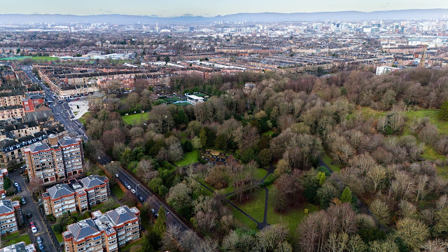
The CHECKPOINT is atop Woodlands Hill, overlooking Kelvingrove Park. The statue is of Field Marshall Frederick Sleigh Roberts, 1st Earl Roberts. He made his reputation as a soldier and national hero in the colonial wars of India and Afghanistan, and in the Boer War in South Africa. There is much controversy over his actions, especially as the man responsible for the brutal crushing of the Boer revolt which involved putting men, women and children in concentration camps.

Kelvingrove Park was created in 1852. The largest monument in the park is the Stewart Memorial Fountain, built in 1872 to commemorate the achievement of Lord Provost Robert Stewart in bringing fresh water to the city from Loch Katrine. There are also statues of physicist Lord Kelvin, chemist Lord Lister and writer Thomas Carlyle as well as the Cameronians War Memorial. The park also contains the Kelvingrove Art Gallery and Museum, opened in 1901 as part of the Glasgow International Exhibition.
On Gilmorehill, opposite the checkpoint, is the main campus of Glasgow University, First established in 1451, its the 4th oldest in the UK after Oxford, Cambridge and St Andrews. Its present building dates to 1870 and were designed mainly in the Gothic revival style by George Gilbert Scott, The main building contains the 85m tower (built in 1887 and the 2nd tallest building in Glasgow after the Science Centre tower) and two quadrangles, and also incorporates the Unicorn & Lion staircase which dates back to 1690 and was moved from the old building on High Street.
Depending on your route choice, you may go up University Avenue. Opposite the entrance to the main campus is the circular McMillan Reading Room, completed in 1939 and described as "an exceptional example of a purpose built reading room designed for a higher education setting. The building exhibits an innovative design style, particularly in its use of brick and concrete, and survives relatively unaltered" Modelled on the Pantheon in Rome.

Next to it is Wellington Church, built in 1874 in the neoclassical style:

If instead you go up Gibson Street you will pass, on your right on Oakfield Avenue, a terrace designed by Alexander Greek Thomson in 1865.

The CHECKPOINT is at Notre Dame School, designed by T S Cordiner.
Scandinavian influenced, Cat A listed, built 1949-53 on the site of the former Observatory. This observatory was owned by Glasgow University and built in 1841. When the observatory had to move location, this building was demolished. The observatory is now at Cochno in the Kilpatrick Hills.


Looking forward, here's a broad aerial view (taken 1950) with the Checkpoints marked at Notre Dame, then Cleveden, Gilshochill, Lambhill and Ruchill:

After the Notre Dame checkpoint you may pass close to the Elstow villa (5 Victoria Circus) a baronial style villa built in 1856.
Then you will probably pass Struthers Memorial Church of Scotland, 52 Westbourne Gardens, 1881, John Honeyman. Built as Westbourne Free Church, it is Italian Renaissance style with fine detailing. Corinthian above Ionic twin columns supporting pediment of shallow portico. Two bell towers with ogee lead domes. It also has a nice war memorial.
,


From the checkpoint you go down and through the site of Kelvindale Paper Mills (on Fortinghall Avenue) :

and then you go up the path above the river to turn onto the Forth & Clyde canal - developed from 1768 and fully opened in 1790.
You then cross The Kelvin aqueduct. This was built between 1787 and 1790 as part of the section of the Forth & Clyde Canal from Maryhill to Bowling designed by Robert Whitworth to complete sea-to-sea navigation. It takes the canal over the river Kelvin. When it opened, the aqueduct was the largest canal aqueduct in Europe.
Robert Whitworth also designed the flight of five locks, which together with the aqueduct were the largest and most expensive works on the whole canal. The canal was reopened to navigation in 2001 as part of the Millennium Link project.
Kelvin Dock – the basin just off the Canal at the 5 rise, amongst other things built landing craft for DDay. opened in 1790, closed 1962. It was used both for shipbuilding and for repairing. The settlement of Maryhill was also originally known as Kelvin Dock (photo taken in 1967):

CHECKPOINT is outside the former Maryhill Primary School, opened in 1884 and closed in 2009. It's now flats. Greek Revival style, Cat C listed:

You will then pass (or even cross!) the stunning new Stockingfield Bridge (opened in late 2022), with its own series of artworks nearby.
You are now in the Ruchill area: The Glasgow Branch of the Forth & Clyde Canal was lined with important canal-served industries for most of its length. At Ruchill there was a sawmill and paint, lead and rubber factories. Stockingfield Junction is where the Glasgow Branch (serving Ruchill, Firhill, Hamiltonhill and Port Dundas), left the main Grangemouth-Bowling section of the Forth & Clyde Canal.
On Lochburn Road were the Kelvindale Chemical Works.
On the way to Lambhill you may (!) go through the Halloween Pend: a tunnel for drovers and their cattle linking Hillend and Lochend. It was built around 1775 and has a distinct bend in the middle so you cannot see from one end to the other.
Lambhill - many residents worked in the nearby pits at Cadder (there was a disaster in 1913 when 22 miners died in a fire). There was also an Ironworks: This works was founded in 1881 by R Laidlaw & Son, gas and water engineers, on the banks of the Forth & Clyde Canal, in which it had a wharf. These Glasgow works made heavy equipment, such as pipes, gas holders, retort fronts, purifiers for the gas industry, as well as piers, and water works equipment.

You then go up Hillend Road to the CHECKPOINT at the top of Lambhill. At one time John Logie Baird stayed in a house on this road. This 1990 photo, looking north, shows the checkpoint towards the bottom left:

On the way back and across to Ruchill Park you will pass close to the site of the former Ruchill Hospital. This was built in 1895 as Glasgow's 2nd fever hospital. It closed in 1998 and was demolished in 2012. The water tower (Cat A listed) still stands, a prominent local landmark. New housing has now been built on the site.
The CHECKPOINT is at the flagpole which sits on top of an artificial hill, which is known locally as "Ben Whitton" after the Parks Superintendent James Whitton who developed the park after its opening in 1892.

As you go down from the park, you will pass Murano Street, which has some nice tenements. It is named after an island near Venice famed for its glass production. The street was once home to two glassworks, both of which opened in 1874. Photo shows the tenements after a major refurbishment in 1978, with park and flagpole beyond:
On the way to the next CHECKPOINT in Cowlairs Park, you may pass the former Hamiltonhill Claypits, recently redeveloped. The Claypits were the source for the clay used to seal the Glasgow spur of the Forth & Clyde Canal. The area became a Local Nature Reserve in 2016 and a new bridge across the canal was opened in 2023: Photo shows this new bridge, with the Partick Thistle football ground beyond:

Then you pass the old warehouses at Applecross Basin, where there's a footbridge across the canal. These are thought to date to about 1786 and first served as a base for a coach service into Glasgow from the canal terminus and later, when made redundant by the canal extension, they became maintenance workshops for the canal company:

The bridge, known as Rockvilla Bridge, is a much restored bascule bridge.
Rockvilla is the old name for this area, dominated by sawmills as it saw rapid growth once the canal was built.
Just beyond the bridge, the canal crosses Possil Road by a double aqueduct, the original was built in 1790 and the replacement in 1880 and both still stand.
Just up from the north side of the bridge stands the Old Basin House, dating from around 1790, Cat C listed. Recently restored, it now houses a cafe. It stands at what was originally the terminus of the canal in 1777 before it was extended into Port Dundas in 1791 to link up with the Monklands Canal.

Just below the checkpoint - on Saracen Street - is St Teresa's RC Church, built in 1960 and designed by Alexander McAnally:
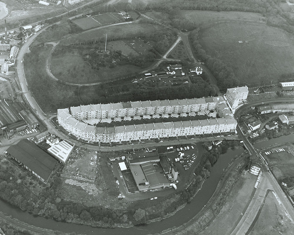
Just beyond the checkpoint - on Carlisle St - is the site of the Cowlairs Works, built from 1842 for the Edinburgh & Glasgow Railway and the North British Railway. A very large complex of workshops, stores and offices, forming the central locomotive, carriage and wagon works of both railways. Closed in 1968 and then demolished, though you can still see a post from the old building at the junction with Inverurie St.
This 1942 photo looking north shows the Cowlairs Works, and also if you look carefully, the "ring" in Sighthill Cemetery which is the next CHECKPOINT!

NB: from the Sighthill checkpoint to the finish, the route is described in the EAST blog.

Comments
Post a Comment